From
Radial Cars to Rubber
Tires
 |
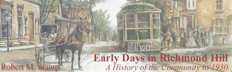
| The automobile and the horse
and buggy compete for attention on
Yonge
Street. |
During the first week of
August in 1914, the same week that Europe went to war, the provincial highways
department took a census of
Yonge Street traffic.
Each day from seven o'clock in the morning until seven o'clock in the evening,
from August 3 to August 9, departmental employees counted the number of
vehicles passing
Jefferson Post
Office between
Richmond Hill and
Oak Ridges. They
recorded an average ratio of 170 motor vehicles to 22 horse-drawn vehicles per
day - a ratio of almost 8 to 1.
13
 |
| The first
gasoline pump north of Toronto in Thornhill, established by
John L.
McDonald, circa 1921. Department of Highways, Ontario. |
By 1914, the rush to the rubber-tired vehicle was well
underway. Just fifteen years earlier, in April 1899,
The Liberal had made note of the first
horseless carriage to pass through
Richmond Hill, and in
1902
Dr. Rolph Langstaff
became the owner of the village's first automobile - a spanking new Oldsmobile
touring car. In 1912, letters to
The Liberal debated the merits of raising
speed limits to thirty kilometres (about twenty miles) an hour in rural areas
and twenty-five kilometres (about fifteen miles) an hour in villages. In the
early 1920s,
Herbert Hall
opened
Richmond Hill's first
gasoline service station, while
Trench Carriage
Works witnessed a drastic slippage in business.
14
After the
First World
War, the automobile seriously started to take over
Yonge Street. The
summer of 1924 witnessed a daily average of 4132 cars whizzing by the
Langstaff
intersection; by 1929, the average reached 5792. Motor trucks soon joined the
passing parade. Then came motor buses - from two a day in the summer of 1924 to
twenty-one a day five years later.
15 With the new motorized perambulators
came more traffic infractions and an overworked village constable. Finally, in
August 1929, council came to his aid by petitioning the Ontario government to
establish a traffic court in the village. Within a week, the province named
Garnet H. Duncan
as magistrate for
Richmond Hill's first
traffic court.
The invasion of the automobile also meant that roads
had to be upgraded and consistent standards of quality had to be met across the
province. So it was that
Governor Simcoe's
former
Yonge Street stump
trail passed from county to provincial ownership in 1920. Three years later, a
new asphaltic concrete pavement was laid from Toronto north to
Richmond Hill,
replacing the old nineteenth-century macadamized gravel surface.
Vehicles powered by internal combustion soon took
precedence over the radial railway, known as the Lake Simcoe line and operated
by the Toronto Transportation Commission (TTC) in the late 1920s. Both
passenger and freight traffic fell steadily during the 1920s as more and more
people bought automobiles and small businesses purchased motor trucks.
 |
| Track work on the
radial railway
line, October 1927. Toronto Transit Commission |
As traffic and revenues declined, radial service was cut
back. The
Schomberg
and Aurora branch line ran for the last time on June 10, 1927, and rails
were removed from the right-of-way over the next few months.
Bond Lake Park
closed forever following the 1928 summer season; the property was eventually
sold for $60,000. Radial runs on
Yonge Street were cut
in half and co-ordinated with new
Gray Coach bus service
between Toronto and
Newmarket.
Finally, in the spring of 1929, the TTC announced
plans to end radial service on
Yonge Street.Richmond Hill and
other communities along the line mounted strong protests and
York County council
hired engineering consultants to fight the decision. Negotiations dragged on
for a year, but to no avail. Shortly after midnight on March 16, 1930, the last
radial car trundled down the tracks from
Newmarket through
Richmond Hill to its
southern terminus at Hogg's Hollow.
Not quite the last. On July 17th, three months after
initial abandonment, radial cars returned to the stretch of
Yonge Street that ran
from
Richmond Hill south
to the Toronto city limits. The reprieve followed a last-minute rescue
operation by
Richmond Hill village
council and the townships of
Markham,Vaughan, and
North York. The four
municipalities purchased the line, renamed it the
North Yonge
Railways, and contracted with the TTC to run it.
So radial cars still ran along
Yonge Street south of
the village for another eighteen years. Hourly service continued between
Richmond Hill and
Toronto, half-hourly in peak periods. The single fare to Toronto was thirty
cents, round-trip tickets were fifty-five cents. The TTC invested in track and
overhead improvements, installed a new signal system, and even purchased land
at the north end of
Richmond Hill for a
future track loop.
16
Despite this second life for the
radial railway,
the rubber-tired vehicle now owned
Yonge Street. Daily
traffic at
Langstaff Corner
during 1930 averaged 8374 automobiles and 78 buses.
17Yonge Street itself
was one of the new King's Highways of Ontario, proudly bearing its
Number 11
designation.
 |
| Paving
Yonge Street
through
Richmond Hill in
1927. Department of Public Highways of Ontario |
 |
| Automobiles claim ascendancy
on the stretch of
Yonge Street
between
Carrville and
Major
Major
Mackenzie drives, circa 1930. City of Toronto Archives James collection
1195 |
Yonge Street had
triumphed over yet another transportation revolution. Route of the solitary
horseback rider and pioneer settler's wagon in the late eighteenth and early
nineteenth centuries, the thoroughfare had thrived with the stagecoach era of
the 1830s and 1840s, survived the challenge of the steam railway in the 1850s,
incorporated the electric railway
in the 1890s, and now it embraced the automobile.
 |
| The last crop on the
Palmer Farm,
south half of lot 45, Concession One,
Markham
Township, 1922, with
Richard
Stephenson cutting grain. |
 |
| Mr. Paxton
ploughing a field where the
Richmond Plaza
sits today. |
Like earlier transportation revolutions, the coming of the
automobile stimulated yet another wave of development along
Yonge Street. Long
strings of homes sitting on five-acre (two-hectare) lots began appearing along
the highway south of town as early as 1910. That year, the
McLean
farm was transformed into the first registered residential subdivision on the
west side of the road between
Langstaff and
Carrville roads -
the emerging community of
Richvale.
 |
| The
Scott Farm
on
Scott
Drive. |
Many of
Richvale's new residents
were commuters who drove to work in Toronto each weekday morning and back in
the evening. Growth was slow at first, because of the lack of public utilities,
but gradually
Richvale began to take
shape.
Richvale School on
Spruce Avenue
(originally SS No. 24 Vaughan Township)
held its first classes in the basement of the local
Methodist
Church in 1923; nine years later, in 1932,
Richvale Post
Office was opened.
 |
| The approach from
Yonge Street.
Archives of Ontario |
 |
| Parking and picnicking.
Archives of Ontario |
Yonge Street strip
development was less intense north of town, yet there, too, the automobile
helped to obliterate distances and drew once-scattered communities closer
together. By the 1920s,
Elgin Mills looked more
like the northern end of
Richmond Hill than a
separate hamlet.
Oak Ridges was described
as a "thriving community," with "one of the best rural school buildings in
these hereabouts."
18 Meanwhile, at
Lake Wilcox, more and
more small parcels of land were being bought for summer cottage lots by city
dwellers. The lake's earliest cottagers had commuted by radial car; now their
summer neighbours were using their cars to escape summer in the city.
The automobile, the radio, and the increased mobility of
the 1920s brought
Richmond Hill and its
neighbouring hamlets closer to the metropolitan embrace of Toronto. Council
took advantage of this phenomenon by erecting signs at either end of the
village proclaiming
Richmond Hill as
"Toronto's Highest and Healthiest Suburb." Nevertheless,
the community retained its own identity as a distinctive residential and
commercial village. Now, at the end of the 1920s, with its muncipal
institutions and infrastructure firmly in place, with its church towers still
dominating the surrounding countryside, and with an economy sparked by its
blossoming greenhouse industry,
Richmond Hill faced
the future with confidence.
Notes
13.
Ontario,Annual Report on Highway Improvement,1915,p. 110.
14.
The Liberal,April 27, 1899;
March 28, and
July 25, 1912.
15.
Ontario,Annual Report of the Department of Public
Highways, 1923-1924-1925,p. 113;
Ontario,Annual Report of the Department of Highways,
1929,p. 105.
16.
Robert M. Stamp,Riding the Radials: Toronto's Suburban
Electric Streetcar Lines(Erin:The Boston Mills Press,1989),pp. 149-58.
17.
Ontario,Annual Report of the Department of Highways,
1930 and 1931,p. 129.
18.
The Liberal,November 29,
1923.
Previous
Next
Copyright © Richmond Hill Public Library Board, 1991
|