|
|
|||
|
Table of Contents |
Governor Simcoe Plans the Road
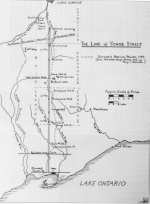
With the outbreak of war between France and England in 1793, and the possibility of American intervention in support of their French allies, Simcoe realized that the capital of Upper Canada at Newark (later Niagara-on-the-Lake) and his Lake Erie water route to Detroit and Michilimackinac were exposed to attack. He countered with a series of bold and decisive moves. First, Simcoe transferred the capital across Lake Ontario from Newark to Toronto Bay, where he founded the town of York. Next, he laid plans for two major roads to strengthen land communications with Michilimackinac and other trading posts on the Upper Great Lakes. The Governor's Road, also known as Dundas Street, would run west from Toronto to the Detroit River. A second road, named Yonge Street, would strike north from Toronto to the Holland River, providing a new link with Georgian Bay, Lake Huron, and Michilimackinac. Simcoe knew of at least one old Indian trail running north from Toronto - the so-called Toronto Portage, or Toronto Carrying Place, that extended from the mouth of the Humber River to the west branch of the Holland River - and he seems also to have been briefed on the general topography of the area. "I have good Information that a Road is very easy to be made to communicate with those waters which fall into Lake Huron," he wrote to Alured Clarke, lieutenant-governor of Lower Canada, at the end of May 1793. 1 Four months later, Simcoe strengthened his case for a Yonge Street route by adding commercial factors to his initial military considerations. "There is little doubt," he informed Henry Dundas, British Secretary of State, "but the produce of the Lands on this Communication will in no distant period be sufficient to supply the North West Trade with such provisions as it may, and which the Merchants concerned in that Trade constantly represent as the principal Utility." 2 Simcoe was now determined to explore the country north of Lake Ontario to determine the best route for his road. On September 25, 1793, together with a small party of officials, soldiers, and native guides, he set out from the mouth of the Humber River. They travelled by horse to the end of the Carrying Place on the west branch of the Holland River near present-day Kettleby, then by canoe through difficult, marshy waters to Lake aux Claies, which the lieutenant-governor renamed Lake Simcoe, in memory of his father. From Lake Simcoe, they went on to Lake Couchiching and down the Severn River to Georgian Bay on Lake Huron. But for the future community of Richmond Hill, the most decisive leg of Simcoe's autumn excursion was the return trip from Lake Simcoe to Toronto during the second week of October. From Holland Landing,Simcoe and his party headed south on a new trail revealed to the lieutenant-governor by Old Sail, an Ojibway Indian, one that avoided the difficult marshes along the upper Holland River. 3 This new trail took them east of present-day Newmarket and Aurora, crossed to the west of the future Yonge Street around Bond Lake, then to the east side again at Elgin Mills, south across the branches of the Don River at Thornhill and York Mills, and finally southwest to Lake Ontario. Deputy provincial surveyor Alexander Aitken recorded the party's return trip in his diary: Oct. 12th. Set off at Daylight & after missing the Path several Times breakfasted at a Brook distant about six miles from our last night's encampment. After Breakfast set out and travelled about Six Miles further and encamped on a branch of the Humber. [This would be the East Humber River, the branch flowing out of Lake Wilcox.] 13th. Got onto a small branch of the Don River and breakfasted distant about four miles from our last encampment, passed a small Pond about a mile & a quarter from where we set out from after breakfast, travelled 6 or 7 miles further to another Branch of the Don & encamped. [A day's trip from just east of Elgin Mills to a point southeast of Thornhill.] 14th. Breakfasted on a third branch of the Don about four miles from last camp & about a mile and a half further crossed the 4th Concession Line of the Township of York between Lots 20 & 21 [and] got to York before three o'clock. 15th. Employed at the Governor's laying down His Excellency's Route from York to Lake Huron. 4 Simcoe communicated his delight to Secretary of State Dundas on October 19. "I have ascertained by a Route hitherto unknown but to some Indian Hunters, that there is an easy Portage between York and the Waters which fall into Lake Huron of not more than thirty miles [about fifty kilometres] in extent, and through a Country perfectly suited for agricultural Purposes." He proposed immediate action. "I have directed the Surveyor early in the next Spring to ascertain the precise distance of the several Routes . . . and hope to compleat the Military Street or Road the ensuing Autumn," Simcoe concluded. 5 Dundas responded with support. "The Communication which by Your vigor & assiduity you have been enabled to trace between York & Lake Huron, is of great importance & must prove beneficial to the Province in the several points of view in which you have considered it," he wrote. 6 Thus was the great road conceived. Unlike the Carrying Place and the Don River- Holland River Indian trails, Simcoe's new route would not follow the natural contours of the land. As a "Military Street," it would run straight as an old Roman road, from York to Holland Landing. The lieutenant-governor had already decided on the name - Yonge Street, after Sir George Yonge, an influential family friend and secretary of war in the British Cabinet. Notes2. Simcoe to Henry Dundas, September 20, 1793, in Cruikshank, Simcoe Correspondence,vol. 2,p. 62. 5. Simcoe to Dundas, October 19, 1793, in Cruikshank, Simcoe Correspondence,vol. 2,p. 90.
Previous Next Copyright © Richmond Hill Public Library Board, 1991 |