|
|
|||||
|
Table of Contents |
The Spinal Cord of the Community
The future, too, announces its presence along this Yonge Street lifeline. Signs of growth are everywhere. Population figures rise annually on the Richmond Hill town limits sign near Langstaff Road. New commercial and residential developments sprout on the left and right as we drive north across the Carrville Road/ 16th Avenue intersection. How significant that a real estate office should occupy the southeast corner of Yonge Street and Major Mackenzie Drive, where Richmond Hill pioneer Abner Miles first settled almost two centuries ago. Still, links between past and present remain strong. As Yonge Street rises in elevation south of Major Mackenzie Drive, we glimpse the picture-postcard church spires that dominated the village of Richmond Hill in the latter years of the nineteenth century - Anglican and Presbyterian churches on the west side of the street, Methodist and Roman Catholic on the east. North of the first set of spires, as traffic slows through the core of old Richmond Hill, we are surrounded by more reminders of former times. On our left, the McConaghy Centre reverts in our imaginations to its earlier life as Richmond Hill Public School, while the municipal offices once again become Richmond Hill High School. To our right, the old radial railway station reappears in our mind's eye on the northeast corner of Lorne Avenue and Yonge Street. North of the town centre, the string of automobile dealerships reminds us that Yonge Street brought the automobile as well as the stagecoach and the radial railway to town. Development seems solid along both sides of the highway. Yet the Elgin Mills Road intersection reminds us that Elgin Mills was once a distinct community, quite separate from its southern neighbour, Richmond Hill.
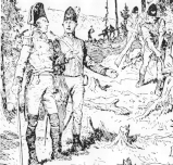
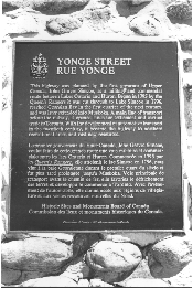
At Bloomington Road the highway leaves Richmond Hill's town limits, enters the Town of Aurora, and begins its descent to Lake Simcoe. It is time to reverse direction and return south to the entrance of the Summit Golf and Country Club. Here, on the east side of the highway, about halfway between Stouffville Road and 19th Avenue, stands the Yonge Street cairn, a stone and mortar structure about two metres square and three metres high (six feet square and ten feet high). Erected in 1937 by the Historic Sites and Monuments Board of Canada to commemorate the historic role of Yonge Street, the cairn reads: The highway was planned by the first governor of Upper Canada, John Graves Simcoe, as a military and commercial route between Lakes Ontario and Huron. Begun in 1795 by the Queen's Rangers, it was cut through to Lake Simcoe in 1796, reached Georgian Bay in the first quarter of the next century, and was later extended into Muskoka. A main line of transport before the railway, it opened lands for settlement and carried trade to Toronto. With the development of automotive transport in the twentieth century, it became the highway to northern recreational areas and vast new resources. From the last decade of the eighteenth century to the final decade of the twentieth, Yonge Street has been the spinal cord of Richmond Hill. The community's pioneer settlers struggled up the road when it was little more than a trail through the bush as they arrived to claim their land grants. As an inland community, Richmond Hill relied on Yonge Street for communication with the Town of York and the rest of the world. Richmond Hill residents of the early nineteenth century prospered from the stagecoach traffic that rumbled along Yonge Street, opening hotel and tavern businesses to serve travellers. The next generation relied on Yonge Street to keep the community alive when it was bypassed by steam railways. Then, at the end of the century, their grandchildren benefitted from the electric railway that shot up Yonge Street from Toronto. Today the road is travelled by cars, trucks, and the GO Bus, its four lanes of paved highway surrounded by residential subdivisions and shopping centres. Yonge Street has left its mark on the history of Richmond Hill. In fact, without the highway, there would have been no Richmond Hill at all. With Yonge Street and because of Yonge Street,Richmond Hill developed from the status of tiny farm settlement to major stagecoach stopping place, then from sleepy Victorian village of the late nineteenth century to a dynamic community poised at the threshold of the twenty-first century. The history of Richmond Hill begins with the creation of Yonge Street.
Previous Next Copyright © Richmond Hill Public Library Board, 1991 |